The Drive from Mazatlan to Lo de Marcos, Nayarit: Confusion, No Shortage of Dried Shrimp, and Then the Prize in a Disneyland-like Jungle
 So there we were, in our van, after taking the Baja Ferry from La Paz and disembarking at the port at Mazatlán.
 Given that we had just spent more than six weeks in the Baja California desert, even in the parking lot of the harbor in Mazatlán, we were struck by the profusion of plant life. Palm trees, vines, and other types of jungle shrubbery seemed to be growing everywhere, sometimes on top of each other, successfully utilizing any amount of even the smallest patch of what looked to be very rich soil and plenty of moisture. We couldn’t tell if they were planted, or just grew. The hills in the far distance were completely covered with greenery. Even in the parking lot of this typical harbor in which “create beautiful surroundings” did not appear to be a high priority, parts of it were indeed beautiful. It was also very noticeably more humid, which of course, you need in order to get all the plants.
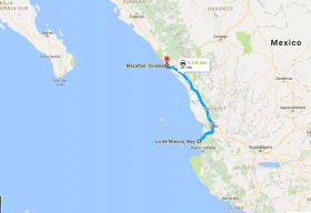 Very unfortunately, our plans in Mazatlán fell through at the last moment, which is a big shame, because from the little we could see of it, Mazatlán looked beautiful and interesting. Our next stop would be Lo de Marcos, a small, mostly Mexican seaside town in the state of Nayarit, about an hour north of Puerto Vallarta and about four hours from where we sat, a bit lost already, at the port in Mazatlán.
 Jet and I looked at each other.
It was time to go.
After several guesses, we figured out where to exit, and made a right onto a busy two-lane road.
Now what?
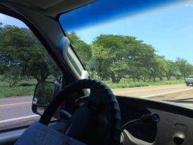 As we had so many other times in Mexico, we found our way through a combination of “The Five Methods”:
 - Several paper maps, none of which were especially good, useful, or even accurate.
- Google Maps (doesn’t work without a cell signal, so good luck with that if you have Sprint / Moviestar as we did) and / or Sygic, which is an app for your smartphone that’s supposed to work without a cell signal. Sometimes it does, and sometimes it doesn’t. Sometimes it’s accurate, and sometimes it takes you on route so strange that it strains credibility so much that you wind up not trusting or using it.
- Asking people. Some know where things are, and some don’t. Some who don’t, admit it, while others just tell you to “continue derecho” (“continue straight,” which we heard all the time and is a good laugh, especially when there are dozens of choices to make along the “straight” path other than just “continuing”). “Asking people” was also a bit of a challenge for us, given that our ability to speak and understand Spanish is limited.
- Knowing and applying basic geography, which works great for general directions. For example, we needed to go south, so we just kept keep the Pacific Ocean to our right.
- Dumb luck, combined with being observant. We used this a lot, and it was amazing how often it worked. More than once, we would be blithely driving right past our intended final destination, discovered that we had indeed already arrived, and made a hasty turn into the closest parking spot. Success!
The area around the port is pretty chaotic, with of course, very few signs (actually, I don’t remember a single one) to help you to find your way. Of course, we got lost, and as a result, we were treated to an unscheduled tour of a pretty seedy side of Mazatlán around the port. Crowded one-way streets were filled with any combination of pedestrians going in all directions, stationary carts, little cars, large buses, bike-drawn carts, and now, for the surprised local inhabitants who strained to see us, an unlikely addition— our very large, white van with two lost gringos and what looked to be two dogs in the middle seat. Any port I’ve ever been to has its shabbier areas, so we weren’t surprised. Never, however, did we feel as if we were in any danger.
By employing each of our Five Methods to various degrees, we eventually made it to the turnoff to the entrance of the toll road. The sides of the entrance were jam-packed, shoulder-to-shoulder, with vendors hawking everything from mangos to dried shrimp. 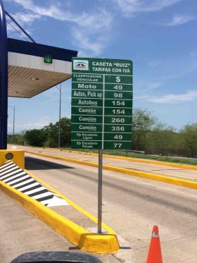 Given that many of them appeared to be selling the same exact same type of mangoes and dried shrimp as the others and there was no real reason to choose one vendor over another, each one would try to make eye contact and motion me over, as if they were hailing me as a long lost friend. These are very hard working people with lots of stamina and a great attitude.
 Given that many of them appeared to be selling the same exact same type of mangoes and dried shrimp as the others and there was no real reason to choose one vendor over another, each one would try to make eye contact and motion me over, as if they were hailing me as a long lost friend. These are very hard working people with lots of stamina and a great attitude.
 After paying our first toll and being let through, it appeared before us: a beautifully maintained, un-crowded, smooth highway, with not a pothole or errant cow as far as the eye could see. Upon fully comprehending the full ramifications of this, Jet searched for and found her Andrea Bocelli CD, which we could now enjoy, given that, rather than bumping along on roads alternating between each imaginable state of repair and disrepair, this one was almost silky (or at least, after experiencing a lot of the opposite for almost two months, it appeared that way).
I don’t know if the highway had signs displaying a speed limit, but if it did, it didn’t seem to matter. Evidently, our 70+ miles per hour was way too slow, if we were to judge by the quantity of vehicles passing us.
In Baja, the road terror we generally experienced was the result of two lane highways having shoulders measured in inches with sheer drop-offs measured in tens of yards, all the while huge trucks barrel towards you at 60 miles per hour from the other direction with almost no room for error.
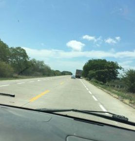 On this toll road, they had devised a new game to play. There were shoulders on each side of the highway that measured about half a lane, so on each side, you would have your lane, as well as about half a lane to the right. The other side of the highway would have the same thing. Any vehicle that is not going well over 70 miles per hour would drive slightly to the right and straddle the combination of the shoulder and their one lane, so the lane marking the left edge of the shoulder would be in about the middle of their vehicle. When you come across one of these slower moving, straddling vehicles, you are expected to pass to the left, which of course, would cause you to take up about half of the lane coming in the other direction. The result would be a virtual middle lane, jointly shared by traffic in the process of passing in both directions.
 This setup encouraged a lot of passing, which happened continuously. If a car was passing from the other direction and didn’t have enough time to pull back into its lane before it hit, let’s say, you, you would be expected to move over in your lane to occupy your half of the shoulder, which would enable three cars to occupy two lanes and two shoulders. This works well if you’re paying attention and have nerves of steel. Of course, if you were passing at the same time as a car coming in the other direction was passing, you would both be in the virtual center lane at the same time with a combined impact speed of perhaps 140 miles per hour. (Four cars in three lanes; no good.) If this happened, your day would probably be ruined.
 We continued like this for a few hours, until we came to a construction area in what looked to be a fairly unpopulated area. Almost magically, though, the vendors appeared on the side of the road, brilliantly taking advantage of the fact that we had to slow down or even stop for the construction, which made it even more convenient to buy their dried shrimp. I love these people!
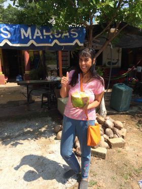
 In a few more hours, we got off the toll road and onto a public road with the more familiar very small or non-existent shoulder setup. After traveling through a highland area through what looked to be the good-sized town of Tepic, we began to descend towards the Pacific Ocean. Along the way, there are several charming, little towns, some of which sold coconut water along the side of the street, which we were very happy to try.
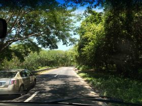
As we got closer back to the ocean, the vegetation got more dense, as we plunged deeper into the jungle. It was like a magical ride at Disneyland where the ride takes you to a themed area that doesn’t really exist in real life as you experience it at Disneyland, but is meant to represent a type of place. Our ride was through the jungle, and we were indeed experiencing it, in real life.
Along our path in many places, the trees from each side of the road formed a canopy for us to drive through, gently but fully engaging our senses. We not only saw the jungle, but as we rolled down our windows, we could feel its wonderful dampness infused with fresh oxygen and smell the combination of musky, decomposing old growth and many times, sweet and fragrant flowers, all while being serenaded by an Italian tenor. Given the sheer, almost shockingly beautiful area we were experiencing, a great calmness overcame us. As the yogis would say, we took a “cleansing 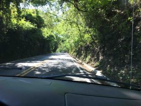 breath,” as our minds cleared, our anxieties melted into the profusion of various palm, mango, papaya, and flame trees all being climbed upon and clinged to by jungle vines, and our desires turned to just relaxing and enjoying the drive. (“Enjoying the drive” is quite an experience for someone like me, who left LA in part because of how much I hated to drive there.)
 breath,” as our minds cleared, our anxieties melted into the profusion of various palm, mango, papaya, and flame trees all being climbed upon and clinged to by jungle vines, and our desires turned to just relaxing and enjoying the drive. (“Enjoying the drive” is quite an experience for someone like me, who left LA in part because of how much I hated to drive there.)
 Time after time, blind curve or not, cars and trucks passed us. Evidently, the long-time residents of the area or those coming from other parts of Mexico such as nearby Guadalajara were not in as calm a mood or were perhaps not as impressed as us with where they were. I guess this is because they see it all the time.
After passing by the beach towns of La Peñita and Guayabitos, we came across a single sign that announced Lo de Marcos. We turned right and peered for the first time down the main street of the little town where we would be staying for the next week.
See links to all Mexico road trip stories below. You are currently reading the one highlighted with the yellow background.
To see hundreds of questions answered by expats already living in Mexico, click here.
To see hundreds of questions answered by expats already living in Mexico, Panama, Belize, Nicaragua and Portugal, go here and navigate to the place you're most interested in.
Sign up for the Best Places in the World to Retire newsletter. To see additional additional pictures and videos not in the stories, follow us on Facebook. To see more videos of the trip, see our YouTube channel.
Want online, interactive help finding the best place abroad for you? Try the Location Advisor.
To download free research studies conducted with over 1,000 expats currently living in Mexico, click here.
Download the free eBook of all the stories below, "Our Year on the Road & Living in Mexico-- Adventures, Challenges, Triumphs, Lessons Learned"
Links to Mexico Road Trip stories:
Editor’s note: you may freely reprint the article above, provided you put this at the beginning or end:
Content provided by Best Places in the World to Retire, which provides credible answers to questions about moving abroad, expat stories, and a location advisor to help you find the perfect place for you.
Content provided by Best Places in the World to Retire, which provides credible answers to questions about moving abroad, expat stories, and a location advisor to help you find the perfect place for you.


.png)