How high are the mountains in Nicaragua, and how does the elevation change the weather?
Carla Fjeld - Ola Verde SA
Nicaragua has lowlands on both the Pacific and Caribbean coasts and highlands with mountains in between. In the highlands, elevations range from 750 to 1,000 meters (about 2,500 feet to 3,000 feet) and there are mountain peaks ranging from 1,000 to 1,800 meters (5,900 feet). These are the famous coffee lands. The weather is distinct in each of the zones, Caribbean coast being very rainy and warm, and the mountainous highlands with cooler temperatures in the 60's at night and 70's...
Nicaragua has lowlands on both the Pacific and Caribbean coasts and highlands with mountains in between. In the highlands, elevations range from 750 to 1,000 meters (about 2,500 feet to 3,000 feet) and there are mountain peaks ranging from 1,000 to 1,800 meters (5,900 feet). These are the famous coffee lands. The weather is distinct in each of the zones, Caribbean coast being very rainy and warm, and the mountainous highlands with cooler temperatures in the 60's at night and 70's during the day. Another way the highland peaks change the weather is by preventing some of the moisture-laden air from the Caribbean coast from reaching the Central highlands and Pacific coast, so these are both somewhat drier areas than the Caribbean coast.
Posted April 17, 2014
Gabriel Sánchez - PRONicaragua
 Nicaragua has three regions, going from the Pacific, on the west coast, to the east, to the Caribbean:
 - The Pacific is close to sea level and it’s not so humid.
- The mountain range has more elevation and is cooler than the other two regions.
- The Caribbean is a plain and it’s humid. It has a lot of rivers and swamps that originate in the mountain range and go all the way to the Caribbean coast.
The major expat areas are...
 Nicaragua has three regions, going from the Pacific, on the west coast, to the east, to the Caribbean:
 - The Pacific is close to sea level and it’s not so humid.
- The mountain range has more elevation and is cooler than the other two regions.
- The Caribbean is a plain and it’s humid. It has a lot of rivers and swamps that originate in the mountain range and go all the way to the Caribbean coast.
The major expat areas are San Juan del Sur, Managua, Granada, Leon, and other areas along the beach in the Pacific. All of these are on the Pacific side of Nicaragua, and have relatively little elevation. It’s relatively warm in this region, and not as humid.
Within the city of Managua itself, on the outskirts, there’s a town called El Crucero, which is very high, very windy, and very, very cool. But if you’re in the central part of the city of Managua, in the capital, it’s hot. If you go to Leon, it’s going to be hot too. Nicaragua is a tropical country. It has a warm weather on the Pacific edge.
As for the mountainous areas, I believe that one of the highest peaks in Nicaragua is a bit over 2,000 meters above sea level. However the territory is very diverse and the Pacific coast is relatively low and as you move to the center, there is a mountain range that basically divides the country in two parts. Within that mountain range, you have many of the highest points in the country and the weather and cities along the mountain range tend to be a lot cooler than the Pacific. You have houses around the forest areas, with pines and you usually have fog at night or at the morning. It is also very windy in these areas. It’s in these parts of the country where coffee is grown because it has the conditions for coffee. There are some areas, for example, Pueblos Blancos where they are up in the mountains and where it’s a bit cooler.
As you move farther east towards the Caribbean, the terrain starts to become a plain again and it’s kind of swampy and very humid. This area of Nicaragua is sparsely populated and has very few expats.
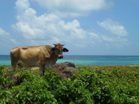
( A cow on Nicaragua's Corn Island in the Caribbean, pictured.)
Posted April 3, 2015
Linda Carlson
 The elevation of the mountains in Nicaragua does change the weather. Matagalpa, where I lived, is between Esteli and Jinotega. In Jinotega, sometimes you have to wear wool pants and a sweater to survive the mornings and then take them off in the afternoons. In Matagalpa, it never gets that cold and you never need to wear winter clothing.
 Managua, which is the capital, is very hot. As you go south of Managua towards Costa Rica, it gets cooler because the area rises in...
 The elevation of the mountains in Nicaragua does change the weather. Matagalpa, where I lived, is between Esteli and Jinotega. In Jinotega, sometimes you have to wear wool pants and a sweater to survive the mornings and then take them off in the afternoons. In Matagalpa, it never gets that cold and you never need to wear winter clothing.
 Managua, which is the capital, is very hot. As you go south of Managua towards Costa Rica, it gets cooler because the area rises in elevation, but still their level of cool is nothing like Matagalpa.
In Matagalpa, except during the hotter months of May and June, some days would be around 80 degrees. It varies from 80 to 90 degrees except for the hottest months of the year, which are April, May, and June. Those months were so hot, I couldn’t wait for summer and fall to arrive. There is a lot of breeze that blows, which cools Matagalpa. I feel comfortable in Matagalpa the whole year except for the months of April, May, and June.
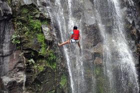
(Cascade rappelling down Salto de la Estanzuela, near Esteli, Nicaragua, pictured.)
Posted August 13, 2015
Dr. Carlos Alemán - Centro de Diseño Denta (Clínica Dental)
 We have a lot of mountains in Nicaragua but they are not really high. If you want to go to a place where the temperature will be a bit colder, you’d want to go to the northern part of Nicaragua.
 There are a couple of departments (states or counties) that have mountains in them, one of which is Jinotega and another is called Matagalpa. These two places have mountains that are higher than most of the other mountains in the country. Estelí is...
 We have a lot of mountains in Nicaragua but they are not really high. If you want to go to a place where the temperature will be a bit colder, you’d want to go to the northern part of Nicaragua.
 There are a couple of departments (states or counties) that have mountains in them, one of which is Jinotega and another is called Matagalpa. These two places have mountains that are higher than most of the other mountains in the country. Estelí is another area that’s in the northern part of Nicaragua that has a high elevation. These places are between one to two hours away from Managua. If you go there, the temperature is going to be way better compared to the Pacific like in Managua, Chinandega, and Leon. It is nice to go to the northern part of Nicaragua and spend a weekend or a couple of days to experience a cooler climate compared to what we have in Managua.
(Cabin in the hills of Jinotega , Nicaragua, pictured.)
Posted November 19, 2016


